Solutions
4DM has create product solutions to support clients business requirements. Solutions have been developed from extensive research and development.
1. Deep Learning Models for Motion Mapping from Sensor Technology
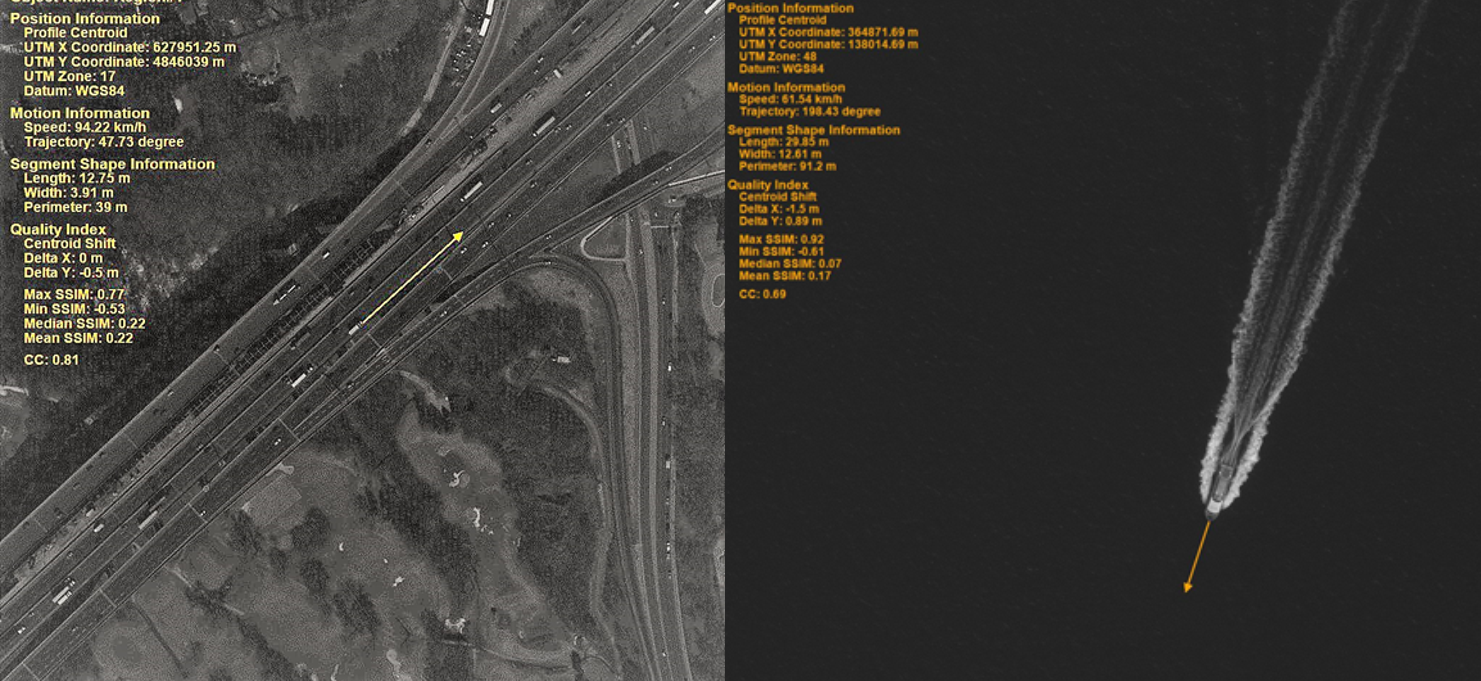
4DM has developed technology that allows for the extraction of velocity, trajectory, size, and count of moving objects from satellite imagery. Our image processing technology provides you with intelligence that can be used in transportation planning, Maritime Domain Awareness and AIS verification. Satellite-derived data make it possible to obtain value-added information regarding objects in remote locations where other sensors may not be available. With global coverage, remote sensing solutions make it possible to cover larger areas, such as a highway corridor, over a single period of time. Presently, satellite constellations, providing global daily coverage over potential areas of interest at sub daily level.
2. Snow Transport Modeling – SnowStream2D – Snowdrifting Modeling
4DM can help you identify snowdrift-prone areas around your roadways, railways, airport runways or other commercial, industrial, or residential infrastructure. Furthermore, our analysis and modeling tools can help quantify the magnitude of your snowdrift issues and develop practical and cost-effective control solutions. Effective snowdrift analysis can decrease the volume of snow that requires plowing and the amount of de-icing materials that needs to be applied to the road after a storm event, resulting in reduced highway maintenance costs, environmental impacts, and hazards through optimized snow clearing scheduling. Our SnowStream2D model predicts cumulative snow flux and accumulation

Map showing the cumulative snow flux over an entire winter season for a section of Highway 400, south of Barrie Ontario.
Our snowdrift solutions can also help with the selection and design of snow control measures, such as proper grading, snow fencing, and landscaping. Using our SnowStream2D model, we can quantify the amount of snow that moves and accumulates over your geographic area of interest. We are able to model small areas at meter resolution or regional levels at hourly time steps for multiple winter seasons. The snow transport/distribution estimates can help you focus your snow management efforts on your most vulnerable assets and spaces. Recommendations provided to our clients are supported by a detailed account of our methodologies, including a complete interpretation and discussion of our modeling results, supported by high quality visualization products (i.e. maps, drawing, and diagrams) which further aid the design and siting of the recommended mitigation measures.

Aerial view of oblique fencing installed along Highway 115, south of Peterborough, Ontario.
3. HydroFlow – LiDAR Processing
4DM had developed a suite of tools for conducting LiDAR hydrological enforcement and hydro – flattening. Using LiDAR to generate digital elevation models (DEM) is now a standard practice. However, when LiDAR data are used for hydrological and hydraulic analysis, issues associated with water bodies arise. Due to the optical properties of water, as the laser pulsed from the LiDAR system hits the water surface it is often completely absorbed or scattered resulting in very few or no signal returns to the sensor. This results in “voids” over the water surface data causing significant distortion when a DEM surface is generated. Post-processing of LiDAR data is often required to correct these issues through a process called hydro-enforcement/flattening which is accomplished through the use of 3D breaklines to define the elevation of waterbodies and watercourses within the DEM. Our team has a detailed workflow, software tools, and IT infrastructure that allow us to efficiently and accurately conduct corrections to DEM. Our methodology involves shoreline extraction using a land/water interface process to create 3D breaklines, and a conflation methodology to remove water artifacts and maintain downstream elevation. Modification to the DEM tiles with shoreline changes is conducted using the breakline and TIN process.

Before (left) and after (right) 3D visualizations of a section of river that has undergone LiDAR hydro-enforcement.
4. Wind Turbine Shadow Flicker Modeling Tool
Recently, the rapid implementation of wind turbines as a source of renewable energy has raised concerns regarding their potential impact to human health. In particular, sunlight traveling through rotating blades can cause a flickering effect on receptors located within the vicinity at particular time of the day and year, given the turbine’s orientation. To map out potential shadow flicker zones, 4DM has utilize ESRI ArcGIS technology to develop a process that can calculate the annual worst- and realistic-case scenarios. The resulting product is map that spatial represents the hourly distribution of shadow flicker throughout the year for a given turbine orientation.

Map showing the worst-case-scenario of the annual shadow flicker generated by three wind-turbines.
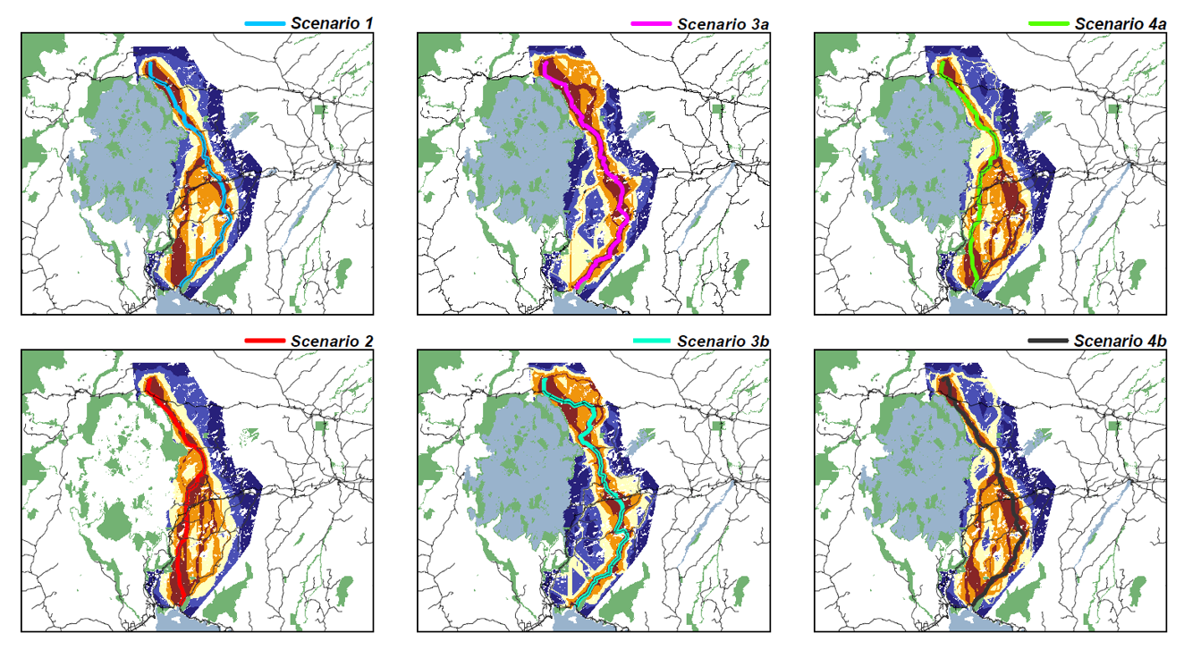
5. iLocate – Siting and Routing Multi-Criteria Modeling Tool
Siting of transmission corridors, oil pipelines, and renewable energy locations are determined by a spatially and temporally complex relationship of engineering requirements, as well as environmental, economic, social, and public health considerations. Using existing research, 4DM has leveraged and enhanced a least impact methodology that includes multi-criteria decision theory to select alternative and preferred siting/routing locations. The model allows for multiple scenarios and has the ability to weigh and rank input variables in a consensus manner. The application utilizes the ESRI ArcGIS environment to support the model.
6. HydrologiX II – Web Based Operational River Forecasting System
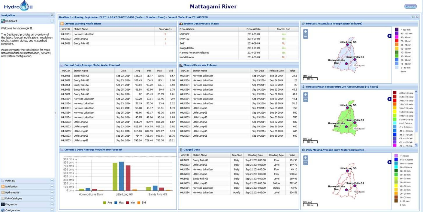
4DM has developed a fully automated web based operational river flow forecasting system by integrating Numerical Weather Prediction (NWP) data, hydrological modeling, remote sensing and web technologies. The HydrologiX II system retrieves and pre-processes hydro-meteorological data from multiple sources, NAM, GFS and Environment Canada’s NWP data from the Regional and Global Deterministic Prediction Systems, historical precipitation data from the Canadian Precipitation Analysis (CaPA) dataset, and hydrometric gauges, and uses these datasets to assemble inputs for a distributed hydrological model (WATFLOOD). Model adapters has been created run other models such as HEC-HMS. The system then runs the model to produce 10-day flow forecast at selected locations in the basin. HydrologiX II also obtains satellite remote sensing data (SSMIS and MODIS) and applies algorithms to produce daily snowpack estimates. The HydrologiX II system includes extensive capabilities for disseminating information internally and externally to the project stakeholders, utilizing OGC compliant: Web Map Service (WMS), Web Feature Service (WFS), Web Coverage Service (WCS), Catalogue Service for Web (CSW), Sensor Observation Service (SOS) and CAP (Common Alert Protocol) for notification.
User interaction with HydrologiX II is conducted through a secure web portal which provides access to numerous visualization, data retrieval and system configuration facilities. These facilities include a dashboard providing a quick visual and tabular summary of the state of the basin and the system; interactive time-series plots for displaying flows and levels; dynamic maps of the basin for displaying reference data (e.g. gauge locations, snow courses, etc.) and various hydro-meteorological spatial data (e.g. 48-hour forecast of accumulated precipitation and temperature, snow water equivalent); configuration panels to control the notification model (notification thresholds and users); diagnostic plots with model results; and options for downloading the model data.
HydrologiX is operational on Mattagami River, Ontario, Churchill River, Labrador and Humber River Newfoundland.